We are dependent on energy for a range of our needs from charging phones to lighting our homes to watching television and to heating our homes in cold regions like Ladakh. Currently, conventional energy sources are further amplifying the impact of climate change and this is expected to be addressed by tapping renewable energy sources. However, in a region like Ladakh which has a delicate ecosystem, there is much trepidation about several large scale energy projects that have been announced so far.
On 18 October, 2023, Press Information Bureau, Delhi released a note that confirmed the approval of a 13GW renewable energy project in Ladakh. The note stated that the project will be completed by 2029-30 and will be implemented by Power Grid Corporation of India Limited (Powergrid) to develop transmission lines passing through Himachal Pradesh, Punjab and Haryana to be integrated with the National Grid. Its estimated cost is projected at INR 20,773.70 crore (INR 207.737 billion) with an interconnection to the existing grid in Ladakh to ensure a reliable power supply to the region. The project will entail setting up of 713 km of transmission line and establishment of terminals at Pang (Ladakh) and Kaithal (Haryana). The announcement of this project was made by the Prime Minister of India, Narendra Modi on 15 August, 2020 in the form of a 7.5GW solar power project. Subsequently, Ministry of New and Renewable Energy (MNRE), Government of India conducted an extensive survey and prepared a plan to set up a 13GW Renewable Energy (RE) generation capacity. Currently the transmission line project is being installed by Powergrid while the solar power project in Pang is being developed by Solar Energy Corporation of India (SECI).
Sources in the government informed us that SECI will first establish a pilot project of 0.5 MW by placing the solar panels at a certain height to allow livestock to graze the rangelands. They explained, “This is based on studies that suggest when the grazing area is provided with some shade the soil moisture content increases and facilitates vegetation growth. The project has not started yet and is expected to start this season. Once the pilot project is complete, more details will emerge.”
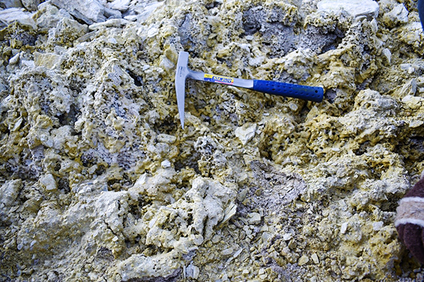
Another renewable energy project that has been announced is a geothermal energy project in Puga for which a tripartite Memorandum of Understanding was signed by ONGC Energy Centre Trust, Ladakh Autonomous Hill Development Council, Leh and Administration of UT of Ladakh in 2021. This pilot geothermal project of 1MW (with a possibility for future expansion) would be India’s first venture into the geothermal sector with the possibility of expansion. This project is located with the Changthang Cold Desert Wildlife Sanctuary. Ironically, there is very little information and details about any of these projects in the public domain as of now.
In order to understand the geothermal energy project, I spoke to Kunzes Dolma, who is currently pursuing her PhD in geothermal energy from Reykjavik University, Iceland. She said, “Geothermal energy harnesses heat from beneath the Earth’s surface to generate electricity or provide direct heating. Unlike solar or wind energy, which are dependent on weather conditions, geothermal energy is a stable and continuous source of power. By tapping into naturally occurring reservoirs of hot water and steam through wells, this energy can be converted into electricity using turbines and generators. Depending on temperature levels, geothermal heat can be used for space heating, greenhouse agriculture, aquaculture (fish farming), industrial drying, bathing, and even snow melting. This versatility makes geothermal energy a valuable resource, not only for electricity generation but also for direct applications that enhance local economies and sustainability.”
She further added, “India has over 344 recorded hot springs, most of which are classified as low-temperature geothermal fields with temperatures ranging from 5 to 80 degree Celsius. Among them, Geological Survey of India has identified Puga in Ladakh as the most promising geothermal site in India. With an estimated power generation capacity of 50 MW, Puga’s geothermal reservoir exhibits high temperatures and significant geothermal activity, making it ideal for developing sustainable energy. The Puga Geothermal Project is currently a pilot initiative with a planned capacity of 1 MW. If successful, it has the potential to be scaled up to 10 MW or more. In addition to electricity generation, geothermal energy can also be used for space heating for homes, schools, and hospitals, reduced reliance on expensive and polluting diesel and coal burning, greenhouse farming for year-round vegetable and fruit cultivation, hot water supply for communities, improved living standards and reduction of fuel-wood consumption, etc. All of this can benefit Ladakh greatly. Harnessing geothermal energy will reduce Ladakh’s dependence on diesel generators, promote energy security, contribute to the region’s goal of becoming a sustainable and self-sufficient energy hub, and reduce the carbon footprint of energy production processes. Additionally, successful implementation could encourage further investment in geothermal exploration across India, making it a key aspect in the country’s clean energy transition.”
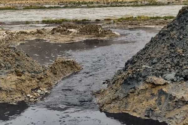
However, questions have been raised on the geothermal project when a blowout incident occurred at the site in 2022 and black discharge/fluid was released into the Puga stream. This was brought to the attention of the media by members of the Wildlife Conservation and Birds Club of Ladakh who visited the site on 16 August, 2022. They approached the Deputy Commissioner, Leh with an appeal for prompt action to stop the drilling. The big question remains about the absence of any precautionary or backup measures as there was a high probability of a breakout as this was the first attempt at tapping the geothermal resources at the site. The discharge should not have been released in the Puga stream and the potential negative impact on the ecosystem highlights the irony of this renewable project.
Environmentalist Narendra Patil had written an article in the September 2022 issue of Stawa with details of this blowout incident. He quoted Geothermal Expert at Iceland Geosurvey (ISOR), Dadi Thorbjornsson as having stated that ‘the discharge was non-toxic and contained bentonite, cement, rock, and water’. He further wrote that there is a likelihood that arsenic was present in the discharge water and added that test results of the water were never made public.
The project faces several other challenges too. Kunzes explained, “Geothermal energy development is still in its early stages in India, and there is a shortage of specialised professionals in this field. Exploration and drilling for geothermal resources requires significant investment, which is one of the reasons India has prioritised other renewable sectors such as solar and wind over geothermal energy. In fact, India still lacks a dedicated policy framework for geothermal energy, which affects long-term investment and development. Furthermore, Puga’s remote location and harsh climate pose numerous logistical difficulties. All essential equipment has to be transported from other states, especially from companies that specialise in oil and gas exploration. In addition, most of the workers involved in geothermal drilling come from lower altitude regions and face health issues in Ladakh’s high altitude and extreme cold and dry climate. Finally, harsh winters limit the work season in Puga to a brief window between June and September, which delays project progress.”
Similarly, we spoke with former Executive Councillor in the Ladakh Autonomous Hill Development Council, Leh from Korzok constituency, Gurmet Dorjey about the solar project. He explained, “The solar project goes back to when we were a part of the erstwhile Jammu and Kashmir state and Farooq Abdullah was Minister of New and Renewable Energy in Government of India and Rigzin Spalbar was the hon’ble Chief Executive Councillor in LAHDC, Leh. When the project was first proposed, we put forward a set of demands and conditions. Our first condition was that when the project was complete, 50% of the income generated from it would be given for nomad welfare. Our second condition was that Ladakh should receive electricity at no cost and finally we demanded that locals would be prioritised for employment in the project. However, there was no response from the government on these demands and there was some delay. Then in 2021, it was finalised and 48,000 acres of land from Skyang Chu Thang was allotted to it including 20,000 acres for the solar project and 28,000 acres for the transmission line. This was decided without consulting anyone from that region.”
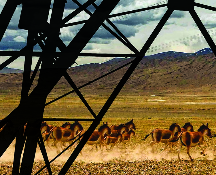
He added that Changthang is rich in biodiversity along with a vibrant pastoralist culture. He said, “The location chosen for the solar project is home to a large variety of migratory birds and 4,000 sq km of the region has been declared as the Changthang Cold Desert Wildlife Sanctuary. My question is that if the solar panels are set up over several kilometres in this area, then where will these birds go? Furthermore, this is the main grazing area for six months for nomadic pastoralists that live in the area between Pang and Kharnak. If this project goes ahead, then they risk losing 30,000-50,000 goat and sheep as their pastures will disappear.”
In an important development, Ministry of Environment, Forest and Climate Change, Government of India published a notification order in The Gazette of India. It constituted the Union Territory level Environment Impact Assessment Authority for Ladakh in accordance with the powers conferred by Environment Protection Act, 1986. The notification states that the State Environment Impact Assessment Authority (SEIAA) will be headed by former Principal Chief Conservator of Forest, Ladakh, Jigmet Takpa, IFS.
We asked Mr Jigmet Takpa about the environmental impact of these projects and how they can be mitigated. He said, “Renewable energy projects do not fall under this authority as per the Environment Impact Assessment Notification, 2006. The reason for this is that renewable energy projects do not cause pollution, do not produce any carbon dioxide or release any discharge. Furthermore, social impacts do not fall under this authority either. If a project is located in a wildlife sanctuary, such as the geothermal project in Puga, then it must get wildlife clearance, which it has already received. The project is not on a large scale as it is located in a wildlife sanctuary.”
Others highlighted the importance of the biodiversity in the area where these projects are located. Director of Snow Leopard Conservancy-India Trust and member of the State Wildlife Board, Ladakh, Dr Tsewang Namgial said, “A wetland is a very important area in a dry place like Ladakh. It serves a number of functions by supporting wildlife including migratory birds as well as livestock, Since Puga is a part of Changthang Cold Desert Wildlife Sanctuary, Ladakh’s State Wildlife Board has given clearance for a geothermal project of 1MW. With regard to the solar projects, we must remember that migratory birds navigate using starlight. If we install solar panels on a large scale it can cause reflective light into the atmosphere, which may interfere with bird migration. This is a concern as Ladakh is an important stopover and breeding ground for many migratory birds including the black-necked crane, which is the state bird of Ladakh.” It is rather ironic that there is very little information available about these projects in the public domain. We tried reaching out to various officials for information and updates about these projects but received no response, including various officials in the Administration of UT of Ladakh. If the end goal of these projects is sustainability and power generation through renewable methods, then there should be transparency about the process of project development and implementation.
By Karuna Chhimed
Karuna Chhimed is a freelance writer based in Leh.