More than names on a map
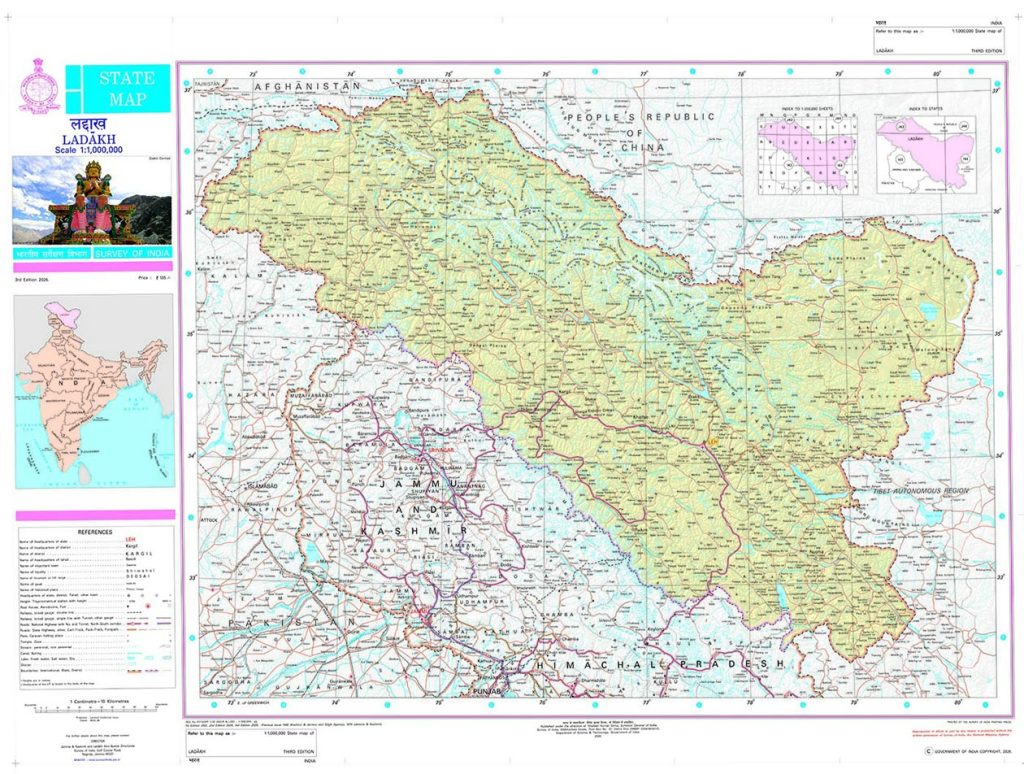
Twenty-eight geographical names have just been added to the official Survey of India map of Ladakh. They may look like small additions in a vast landscape. They are not. Names on an official map become part of the vocabulary to administer, study, and understand a territory. This matters in a place as historically layered and strategically sensitive as Ladakh.
Government of India, along with the UT administration, states that the exercise is intended to facilitate accurate recognition of these places and improve awareness. The list includes geographical features such as peaks, mountains, passes, glaciers, valleys, rivers, and lakes. A map does more than locate a place. It gives geographical knowledge a standard form. The names used by administrators, researchers, schools and the public eventually become part of the permanent record through which a landscape is known. The list reveals more when the names are read not individually but as a pattern.
An older geography of knowledge
Eight of the names have strong associations with Buddhism: Atisha Giri, Kanishka Peak, Kumarayana Point, Sakyasri Giri, Rinchen Zangpo, Guru Rinpoche, Marpa Lotsava Ri and Milarepa Kangri.
Atisha Giri recalls Atiśa Dīpaṃkara, the Indian Buddhist master who travelled to Tibet in the 11th Century and was a key figure in the transmission of Buddhism there.
Sakyasri Giri appears to refer to Śākyaśrībhadra, the Kashmiri Buddhist scholar who was the last abbot of Nālandā and travelled to Tibet in 1204 with a group of Indian scholars.
Rinchen Zangpo was a Tibetan translator who spent years studying in Kashmir and India. In Ladakh, Nyarma, Alchi, Mangyu, Sumda Chun, Lamayuru and Wanla are some important Buddhist sites associated with him. Through these centres, intellectual, artistic and religious influence from Kashmir and India found a lasting expression in Ladakh.
Marpa Lotsava Ri recalls Marpa Lotsāwa, the Tibetan translator who travelled to India and Nepal, studied with Indian masters including Nāropa, and carried their teachings back to Tibet.
Milarepa Kangri recalls Milaraspa, Marpa’s celebrated disciple and one of the best-known figures of Tibetan Buddhism.
Guru Rinpoche, or Padmasambhava, belongs to an earlier layer of this Buddhist world and is associated with the transmission of Buddhism to Tibet.
Kanishka Peak evokes Kanishka I, the great Kushan emperor whose reign is associated with the patronage and expansion of Buddhism across South and Central Asia. In Zangskar, the Kanika Chorten in Sani is attributed to him.
Kumarayana Point evokes Kumārāyana, the father of the great Buddhist scholar-translator Kumārajīva, connecting the name to the Buddhist world of India, Kashmir and Central Asia.
What emerges is more interesting than individual biographies. These names bring together Indian masters, Kashmiri scholars, Tibetan translators, a Kushan emperor and figures from the wider Buddhist world. Their lives point to a landscape that was once a corridor of knowledge rather than a collection of isolated cultural zones. Teachers travelled from India and Kashmir to Tibet; Tibetan scholars travelled south to study; texts and artistic traditions moved across the Himalayas; and Ladakh occupied an important position in these exchanges. The list thus evokes an older geography.
The geography of the present
There is another reason the exercise deserves attention. In a frontier region, geographical names are part of the infrastructure of knowledge. Along with the recovery of an older geography of knowledge, the list also places several locations that have figured in recent border tensions, such as Gogra, Hot Spring and Dehra Compass, within India’s formal national mapping system. The standardisation of a geographical name is therefore not merely a matter of cultural or administrative consistency. It gives a location a defined place in the country’s official cartographic record.
The significance lies precisely in this dual function: Preserving and organising geographical knowledge while establishing a common national reference for places whose location and identity can carry wider significance. Yet no serious map is ever really finished. The landscape it seeks to represent carries layers of nomenclature accumulated over generations, and those layers do not always align neatly with a single standard vocabulary. In parts of eastern Ladakh, the cartographic record sits alongside a much older and more intricate geography of names preserved through local usage and memory.
That is not a weakness of standardisation as much as a reminder of its unfinished nature. A national map provides a common reference point. It need not be the final repository of every name by which a landscape has been known.
For Ladakh, this distinction matters. Its geographical knowledge exists in a mixture of local names, Tibetan spellings, historical maps, oral traditions and modern administrative usage. Some names have several spellings. Some have changed in pronunciation. Others may preserve memories whose origins are no longer immediately apparent. The new exercise should therefore be seen not as the closing of the map, but as an opening of the record.
Building the record
The logical next step would be a comprehensive Ladakh Geographical Names Gazetteer.
Such a record could bring together official and local names, original scripts, pronunciation, historical spellings, linguistic origins where established, coordinates, historical maps, archival references and oral traditions. Where an origin is uncertain, that uncertainty should be documented rather than left to speculation.
There is also a more technical question about the standardisation. For example, the announcement lists the feature as ‘Milarepa Kangri’, while the Survey of India map renders it ‘Milārepa Kangri’. The peak is marked at 6,520m above mean sea level and lies east of Braldu Glacier, at approximately 36.24°N, 76.01°E. The difference may appear minor, but such distinctions matter in a standardisation exercise.
The Tibetan written form མི་ལ་རས་པ་ is conventionally transliterated as mi-la-ras-pa, or Milaraspa in a joined form. ‘Milarepa’ is the familiar Tibetan pronunciation-based rendering. The macron in ‘Milārepa’, however, does not correspond to a long vowel represented in the Tibetan spelling. If a pronunciation-based English form is intended, it should be distinguished from transliteration; if the aim is to preserve the written form in Bhoti/Tibetan, Milaraspa would be a better choice. A map intended to standardise geographical names should make such conventions explicit and apply them consistently.
Such a record would serve several purposes: Administrative consistency, academic research, cultural preservation and a more authoritative understanding of Ladakh’s own geography.
The 28 names have now entered the official map. What should follow is a deeper effort to understand the histories that those names carry. A territory is understood not only by its borders, but by the knowledge accumulated about what lies within them. A map can standardise a name but it should not simplify the history behind it.
By Phuntsog Tsering
Phuntsog Tsering is former Deputy Advisor, Ministry of Defence, Government of India.
The UT Administration should undertake the preparation of the Eastern Ladakh map with due consultation from experienced experts, scholars, and knowledgeable local resources. Such an important exercise requires not only technical expertise but also a deep understanding of the region’s geography, history, traditional knowledge, and local realities.
In this regard, the author with his decades of dedicated work and lifelong experience in the region, possesses valuable knowledge and expertise that could greatly contribute to ensuring that the map is accurate, comprehensive, and reflective of Eastern Ladakh’s unique and important character.